


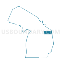
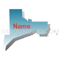
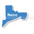
Voting District 0070176000004, Alpena County, Michigan
About
Outline

Summary
| Unique Area Identifier | 595833 |
| Name | Voting District 0070176000004 |
| County | Alpena County |
| State | Michigan |
| Area (square miles) | 4.61 |
| Land Area (square miles) | 4.31 |
| Water Area (square miles) | 0.30 |
| % of Land Area | 93.47 |
| % of Water Area | 6.53 |
| Latitude of the Internal Point | 45.03965920 |
| Longtitude of the Internal Point | -83.50237790 |
Maps


Graphs
Select a template below for downloading or customizing gragh for Voting District 0070176000004, Alpena County, Michigan


Neighbors
Neighoring Voting District (by Name) Neighboring Voting District on the Map
- Voting District 0070174000004, Alpena County, MI
- Voting District 0070174000005, Alpena County, MI
- Voting District 0070176000003, Alpena County, MI
- Voting District 0070176000005, Alpena County, MI
- Voting District 0078768000001, Alpena County, MI
- Voting Districts not defined, Alpena County, MI
Top 10 Neighboring County Subdivision (by Population) Neighboring County Subdivision on the Map
- Alpena city, Alpena County, MI (10,483)
- Alpena township, Alpena County, MI (9,060)
- Wilson township, Alpena County, MI (2,029)
Top 10 Neighboring Place (by Population) Neighboring Place on the Map
Top 10 Neighboring Unified School District (by Population) Neighboring Unified School District on the Map
Top 10 Neighboring State Legislative District Lower Chamber (by Population) Neighboring State Legislative District Lower Chamber on the Map
Top 10 Neighboring State Legislative District Upper Chamber (by Population) Neighboring State Legislative District Upper Chamber on the Map
Top 10 Neighboring 111th Congressional District (by Population) Neighboring 111th Congressional District on the Map
Top 10 Neighboring Census Tract (by Population) Neighboring Census Tract on the Map
- Census Tract 2, Alpena County, MI (4,431)
- Census Tract 8, Alpena County, MI (3,298)
- Census Tract 9, Alpena County, MI (2,910)
- Census Tract 7, Alpena County, MI (2,732)